Hi Everyone!
We are alive…actually more then alive. We did well. Since our return from our adventure race I have relayed this story numerous times already, but I am now determined to get it in writing (or email or whatever) while it’s still fresh in my mind.
As you know, we have been training for our “Big Race” for over a year. It has involved the help and patience of many of you receiving this email…to which we are eternally grateful.
OK…let’s tell the story…it’s a long one…longer then anyone (including us for sure) expected…
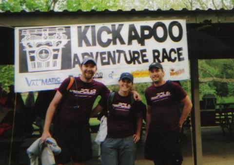
We arrived in Rockton, Wisconsin and we checked in at our cabin. We luckily had booked the only cabin in this hotel-less town in the middle of pretty much nowhere-land. I have no idea where all the other teams and crews stayed.
I want to get to the race story quickly, so I’ll be brief in describing the setting. This is the hilliest of hilliest in Wisconsin…in fact it’s the area home to a lot of Wisconsin’s ski resorts…and part of the race took place in Wildcat MOUNTAIN state park. The area we would be racing in is actually still Indian reserve land owned in part by the HO-Chunk nation. There is a river that winds all over it, with creeks spider-webbing all about…and it had rained ten inches earlier in the week…so every bit of water was up (and every bog full of mud).
So we got geared up, checked in, and we awaited the start…
We had been told at the pre-race meeting that we would need a support crew member present at the start.
The race director, whom I will refer to as Joe here (even though I used many names not to be mentioned here during the race), told us to line up on the opposite side of a tall fence from our support crew. The support crew each had a “Mystery” envelope. Joe told them to open the envelopes and hand us what was inside through the fence. It turned out to be blindfolds. Yes, blindfolds. We were told to blindfold ourselves and then listen to our crew as they directed us to three locations to get 1) a map 2) coordinates and 3) more coordinates and instructions.
Remember they were on the other side of a fence…so we had to listen for them…and also remember there were dozens of other crew members yelling out instructions to dozens of other teams.
It was a silly start, and I felt silly doing it, but I know it was designed to put a little separation between the teams as we started…and it accomplished that.
We got to our three locations and got our three things and took off our blindfolds to see we were second to last to accomplish this feat.
So we ran to a table and set to plotting and marking our maps. We did this actually pretty quickly and efficiently, leaving well ahead of several teams.
The first check-point looked easy. It was just a little down a trail and short jog south through the woods to a ridgeline. The checkpoint was only about a half a mile from the start line.
It ended up that Checkpoint ONE would define us as a team for the race…we would not give up.
Did I mention it was night? 10pm. We were in the woods with flashlights?
Well, we couldn’t find the checkpoint. It wasn’t to be found. Were we in over our heads? Other teams had found it. One hour went by…up and down the hill…east, west, north, south. Two hours went by…up and down the hill…east, west, north, south. Should we quit? Are we really this bad?
Well, at the two hour point 5 teams were still looking for checkpoint one…and we were one of them. All five of us gathered and compared maps…and we all had it plotted in the same spot…and we all agreed it wasn’t at that point.
So, we amassed a huge uber-team and took to the woods like a massive search party. That didn’t work. So we did it again. That didn’t work.
At the three hour point…and everyone’s near breaking point…I found it…by fluke.
I decided to venture further then I should have. I knew I was well south of where it was plotted. I was just north of a stream on the map…and that stream was a full centimeter (eighth of a mile) south of my plotted map point. I could still see my team well behind me…and they were calling me back. I went to turn back and started to slide in the mud…and slid toward the stream…and fell in the mud. As I got up, my light hit the checkpoint marker…a fluke. The marker was south of the stream…and all five teams had the point plotted a full 8th of a mile north. This was the first, but not the last time I cursed Joe’s name.
I also yelled for every other team…we had a pact. One of those other teams still owes me $100 and a power bar (the bounty they put on checkpoint 1).
I have gone back and re-plotted it since…and that marker was NOT in the right place…but we found it.
The important thing was that we hadn’t given up. Lessons were learned.
It was on to checkpoint two. Great! One down…three hours…at that rate we’d finish sometime on Monday…it was 1am Saturday morning.
Checkpoint two was almost as bad, but was my emotional boost for hours to come at the same time.
Checkpoint two was on top of a hill. All we had to do to get to that hill has follow a gravel road for about a half a mile, ford a stream (two feet deep, twelve feet across, with muddy inclines on both sides), follow another road for a quarter mile or so, cross a 100 foot bog to a cliff face, find a way up or around the cliff, and then ascend the hill. The checkpoint would be at the very top.
Well, we were happy to see that our three hours was not going to hurt us. Here at checkpoint two were all the teams we worked with at 1…plus about 10 more teams or so.
Apparently every team had this marked on their map at the top of the hill…us too. Unfortunately, it was NOT at the top of the hill. So, off we set to methodically search every point on this god-forsaken mound.
Again a fluke struck us with luck. After fully searching the east, north, and south sides of the hill…we went to search the west. I had saved the west for last since I knew many teams had come in that way.
At the bottom of the west side of the hill, I found a trail…it was the first I’d seen on this mound. I could still see my team so I decided to follow it up. I was thinking that since I had been in the wrong ravine on CP1…that perhaps I was at the wrong hill on CP2.
I came out of the woods at the top, and turned and yelled to my team “Guys, come here!” I was calling them because I had just found 4-wheeler tracks that went right by the wood (and right to this point). I wanted to follow these tracks and see if Joe had used a four wheeler to perhaps a different trail entrance? I don’t even know if Joe has or uses a 4-wheeler…but it seemed logical…insane I know…but I was grasping at straws.
John and Cortny (my team) came out of the woods. John first, who went over 100 feet to my right and down the 4-wheeler path to pee. Cortny came out second and just to my left. As I moved my light off of John (to give him some privacy), and moved it to Cortny, my light hit the marker…hanging on the trees.
It was determined later that this CP was definitely tampered with. My guess is if you find that 4-wheel owner …you find the guy who moved it.
This time I did not yell out. MANY teams were still looking and we could use the time on them. There was no pact this time. We doused our lights, went completely stealthy, punched our checkpoint under two red LED lights…and made off into the night to CP3.
It was later learned that we were one of perhaps three or four teams to find CP2…and we wore that badge with pride, knowing/hoping it meant a higher ranking
OK, so now it’s 3:30am, and we’re on pace to finish sometime on Sunday…Hey, at least it wasn’t Monday anymore.
Guess what? CP3 wasn’t any easier.
CP3 was exactly were it was suppose to be…only no one was looking there. Why look there? It’s never were it’s suppose to be. So, we followed a horse trail that got us close to it, and went off through the tallest and thickest patch of stinging nettle (
http://en.wikipedia.org/wiki/Stinging_nettle) we’d ever seen. This whole area was a nettle patch.
Here’s how bad it was…WE HAD PANTS ON (not shorts) and we could hardly stand the itching from the nettle chemicals that got to our legs.
We kept walking the nettle in the right area along the river, and walking the nettle, and walking the nettle. Then we crossed the river (waist deep) and walked the nettle on the other side just to keep things fresh. There we talked to a team who had found CP3 and were looking for the trail to CP4, and told us CP3 was on the other side of the river and high up. So we went back across the river, and we walked the nettle.
I will say that the river cooled the nettle sting. We enjoyed that.
John found this one. He looked across the river and there it hung. Yes, if you’re playing along at home, the other team sent us back across the river, telling us it was on the other side, and we found it on the side they were on. So, yes, they purposely pointed us in the wrong direction. Then again they knew we had found CP2…and perhaps they wanted to distance us?
It’s now 4:30am...I think. We had only three checkpoints in 6 ½ hours.
CP4 and CP5 couldn’t have been easier. We blazed down a 2 mile mountain bike trail (in the dark still and on foot still) and they were right on the trail. I had been expecting CP5 to be a supported stop. That means I expected to see our support crew and get supplied. CP5 was the only CP right next to a road and just off a parking lot and camping area. It was about 5:00, and nearing day break soon. I had run out of water just before CP4. Surely CP 5 would be a supply point.
CP5 was deserted. All we found was a water pump with a sign that read “Not tested for drinking! Do not drink!” and a red car with no owner anywhere in site. Why would someone put a water pump at a parking lot next to a small camping area by the woods and NOT test the water? What is that water for? I thought about it for hours and never came to a logical conclusion.
It was on to CP6 a mile away and we started to hit a groove. We tried a trail, it didn’t work. We quickly ditched it and went out of the woods and followed them to an indentation in the tree line. It was a guess. The map read it that way, but we didn’t still fully trust our map. It was there and we moved on.
CP 7 was on top of Mt. Pisgah, which was about a half a mile from CP6. As you might have figured, Mt. Pisgah was a climb, but not that difficult…since the sun was now rising. We found the CP…in the dawn light…in no time.
Before we moved on to CP8 we headed down into Wildcat Mountain State Park, praying to find drinking water…and we did. We refilled our camelbaks from a drinking fountain down in the park. So we now moved off to CP8…which meant we had to climb out of the valley the fountain was in…water came at a price.
We went up to a road, and quick 1.5 mile jaunt to CP8. It was day now, so CP8 should be easily findable. The map had it across the river and on to a peninsula. Wouldn’t you know it…just when we started to trust our maps again…CP8 was clearly in the wrong place. Had we gotten here at night, we would have perhaps never found it.
Cortny found it and pointed it out to us. It was NOT on the peninsula. It was up a cliff and on a hill…but clearly visible in daylight from the peninsula.
We punched the CP and started off toward CP9. Now, to keep this story short, I left out the part about me nearly breaking both legs at CP3…and laying down in nettle till the pain subsided…but I can’t leave out this part. Right here next to CP8, we were attacked by bees. We had just left CP8 and were looking for a nice easy place to cross the river...and I got stung. I yelled and nearly the same time Cortny did, because she had just been stung too. I heard the buzz by my ear just a second before I got stung again…right on my ear. RUN! We ran. There was no sense to it. We just ran…and the bees followed. Cortny fell down into a ravine and landed on her back, but after about two seconds she realized the bees were STILL on us, so she found a way to get up quickly and we ran. We descended to the river pretty much by sliding quickly down in a mud slide, and we started to slow. As we quickly crossed the river, I saw a bee on the extra headband I had on my wrist. It was trying to sting me through the head band.
That headband is at the bottom of the Kickapoo River now. I’ll miss that headband.
(As a side note, one of the bees somehow got in our gear…and it stung Cortny in the van on the ride back to Illinois on Sunday morning.)
CP9 was on top of Wildcat Mountain, an easy climb on the trail. We got it quickly. Again the light of day was speeding us up.
We got CP10 so quickly; I have no memory of it. We must have punched it while moving.
Finally, we came into CP11, the start of the kayaking and a supply point. I nearly hugged Chris, Corey, and Eric - our crew. Of course I was covered in mud, gook, and sweat, so I held back. It was just over 10 hours we’d been moving…and apparently we were somewhere in the middle of the pack.
Eric had went earlier that morning and bought us coffee. There was other food and stuff, but I remember the coffee the most – it was soooo good.
We got in the boats fairly quickly, and got moving.
The distance from CP11 to CP12 is 7 miles in a straight line. However, the Kickapoo River is anything but straight. In fact, “Kickapoo” is Indian for “It goes here and there”…and it did. There is one place on it where it takes you three miles of paddling to get a mile of distance.
The sun was completely up and we were paddling. It was time to enjoy the scenery. It was beautiful. With the exception of occasional bridges, one team we passed, one who passed us, we saw nothing but scenery.
I had a “moment” while kayaking. I started strong, and ended strong. However, somewhere in the middle, I was dying, and Cortny had to take up the slack and see me through.
When we saw our crew again at the end of the paddling, I couldn’t believe we were done. Even though I saw them, I was still asking them if this was really the end of the paddle.
So out of the boats, and it is 1pm. We eat quickly. We plot some new checkpoints on a new map we’re given, and we set out on our bikes. There were two checkpoints before the rappel, and 26 miles between us and the rappel.
Remember this is a 20 hour cut-off race, and we have 5 left.
The bike checkpoints were merciful. Joe obviously placed the first bike checkpoint so we’d be on the easiest road. I didn’t say “easy road”, but “easiest”…as easy as a ride through Wisconsin hills could be.
The second bike checkpoint was at a mountain bike trail head. It was obviously placed so we’d be smart and take that trail. We arrived with two other teams, and all of us were too out of it to realize we should take the trail. We stayed on the road for another 5 miles till we could get on the trail again.
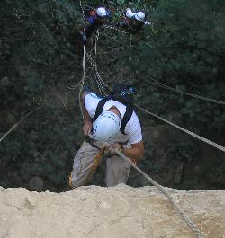
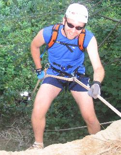
The next thing we knew we were at the rappel, and we clearly were NOT going to have enough time to rappel, and bike another 24 miles to the finish.
We didn’t give up. We pulled ourselves across a river on a rope traverse and we climbed to the top of the rappel (17 stories up). Cortny was a little freaked and did not want to go down. We stopped and had a talk. Since we were NOT going to finish, it was pointless. She would climb down instead. Cortny is brave, and she had gotten me this far, and had carried me through the middle kayaking…I understood. Emotions were amplified by exhaustion.
I was going to go first. I was rigged and about to clip on…and the guy at the top stopped me. He wanted me to switch my rigging. Now, I have trained on 120’ buildings, and I have no fear of heights…just to be clear. However, he might as well have been talking Chinese to me. I could not understand what he wanted me to change or how he wanted me to change it. I do know the change was dramatically different then what I had trained and learned on. My brain was not going to let me figure it out. I calmly explained that I was now utterly confused. I was not about to learn a new way to rappel…I didn’t have the brain power left at this point. Since we weren’t going to finish, I climbed down.
John was doing better (mentally and physically), and he figured out the new system and rappelled down. I wish I could have. He beat me down.
As we approached the rope to re-traverse the river, the rope volunteer told us that a lot of teams were behind…in fact we were doing well. He also told us that the race had now been EXTENDED. There would be no cut-off.
He explained that we could climb back up and rappel down if we wanted it to count.
We would not climb back up, but we were going to finish.
There was little to nothing left in our mental and physical tanks, but we were going to finish this race.
We dropped our climbing gear, stripped every piece of gear not absolutely mandatory. We dropped every ounce of food, every extra thing. We refused to refill our water packs. We wanted to go light.
As I put my pack back on, it actually felt much lighter…and that was good.
24 more miles of biking lay ahead.
We took a slower pace for the first half, but then we caught a mile and a half downhill that got us up to 40 mph. It rejuvenated us, and we managed a much greater pace through to the end.
We pulled into the finish at 8:01 pm. Almost exactly at 22 hours. We had opted to not go get a checkpoint just before the finish, and we hadn’t climbed back up to rappel. At this point we just wanted to cross the finish line…and we did.
Joe looked at our card and told us that if we’d just climbed back up to rappel, and if we’d gotten that short last CP, we’d have placed 2nd.
It wasn’t about placing for us. It was about finishing…and we finished 4th in our division (again)...and I’d guess 13th overall.
Yes, we are already plotting our next race.
Yes, we are crazy, but we’ve always been crazy… now we’re crazy AND healthy!

